Years Experience in
Field of Survey
Takhteet Survey Company stands at the forefront of precision surveying technology in the United Arab Emirates, delivering exceptional land surveying services across Dubai, Abu Dhabi, Sharjah, and beyond. With cutting-edge drone technology, advanced LIDAR systems, and comprehensive 3D modeling capabilities, we transform complex terrain challenges into architectural triumphs.
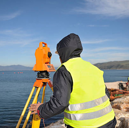
Professional boundary surveys, elevation mapping, and terrain analysis using GPS technology, total station measurements, and drone-based photogrammetry for residential, commercial, and industrial developments throughout the UAE.
READ MOREHigh-resolution aerial photography, orthophotography, and volumetric calculations using professional-grade UAVs equipped with precision cameras and GPS systems for large-scale development projects.
READ MOREMarine and coastal surveying services, including seafloor mapping, depth measurements, coastal erosion monitoring, and underwater infrastructure inspection for port developments and marine construction projects.
READ MOREComprehensive subsurface investigation using ground-penetrating radar, electromagnetic detection, and utility locating equipment to prevent costly construction delays and ensure worker safety.
READ MORECutting-edge laser scanning technology for architectural documentation, as-built surveys, digital twin creation, and BIM integration supporting construction, renovation, and heritage preservation projects.
READ MORETakhteet Survey offers project management and consulting services, taking clients through complex surveying procedures with expert advice from start to finish.
READ MOREAs one of the leading survey engineering companies in the UAE, Takhteet Survey provides several services, including land surveys, aerial surveys, and 3D laser scanning. Our team is here to ensure you get your desired output while meeting the highest industry standards, making us the leading
land survey company in the UAE.
Takhteet Surveys
Takhteet Surveys
Takhteet Surveys
Takhteet Surveys
Takhteet Surveys
Topographic Survey
Takhteet Survey Company operates in a rapidly expanding UAE construction market projected to grow at 3.8% annually through 2028, supported by AED15.8 billion in infrastructure investments. Our strategic positioning capitalizes on the UAE’s commercial construction market growth from USD 42.5 billion in 2024 to USD 56.49 billion by 2030, positioning us as the precision foundation for this unprecedented expansion.
Technology Leadership: First-mover advantage in LIDAR-equipped UAV integration
Project Portfolio Diversity: Proven capability across residential, commercial, infrastructure, and heritage projects
Government Relations: Established partnerships with Dubai Municipality and federal authorities
Market Timing: Positioned for 5.6% construction sector expansion in 2024 and 4.6% average growth through 2028
Digital Transformation Leadership – Pioneering surveying automation and AI integration
Sustainable Development Support – Aligning with the UAE’s 2050 clean energy objectives
Mega-Project Specialization – Targeting billion-dirham infrastructure developments
International Expansion – Leveraging UAE success for GCC market entry.
Technology Integration Advantage
While competitors rely on traditional surveying methods, Takhteet’s integrated technology stack delivers 10x faster data collection with millimeter accuracy, reducing project timelines by 30-40%.
Client Partnership Model
Our embedded partnership approach positions surveyors as strategic consultants rather than service providers, creating long-term revenue relationships and project continuity.
Quality Assurance Excellence
ISO-certified processes and redundant verification systems ensure zero rework scenarios, protecting client budgets and maintaining schedule integrity.
Advanced Technology Integration Our state-of-the-art surveying arsenal includes LIDAR-equipped UAVs, precision drone mapping systems, underground utility detection equipment, and hydrographic bathymetric survey technology. This technological excellence ensures millimeter-accurate results for every project, from residential developments to mega infrastructure ventures.
Prestigious Project Portfolio
Comprehensive Survey Solutions
From aerial data collection surveys using advanced drone technology to underground utility mapping and hydrographic bathymetric surveys, Takhteet delivers integrated solutions that accelerate project timelines while maintaining uncompromising accuracy standards.
We have been using the various services of M/s Takhteet Survey especially for our mobility solutions. One of the precise engineering survey companies with major projects to their credit is a great associate for our projects.
Takhteet Survey is one of the best survey companies we've worked with. The entire team was exceptionally professional and delivered precision data for some of our major projects with the Government entities.
Our Experiences working with Takhteet Survey have been nothing but the best. I can confidently recommend their high quality, professional work for all survey engineering industries and experience their professionalism.
We've relied on M/s Takhteet Survey's services, for our mobility solutions. Renowned for their expert engineering surveys and impressive portfolio of major projects, We look forward to continuing our collaboration with them.
Takhteet Survey is an exceptional survey company in our experience. Their professionalism and precision in delivering data have been successful in executing major projects with government entities.